Record-setting Arctic warmth and sea-ice cover …
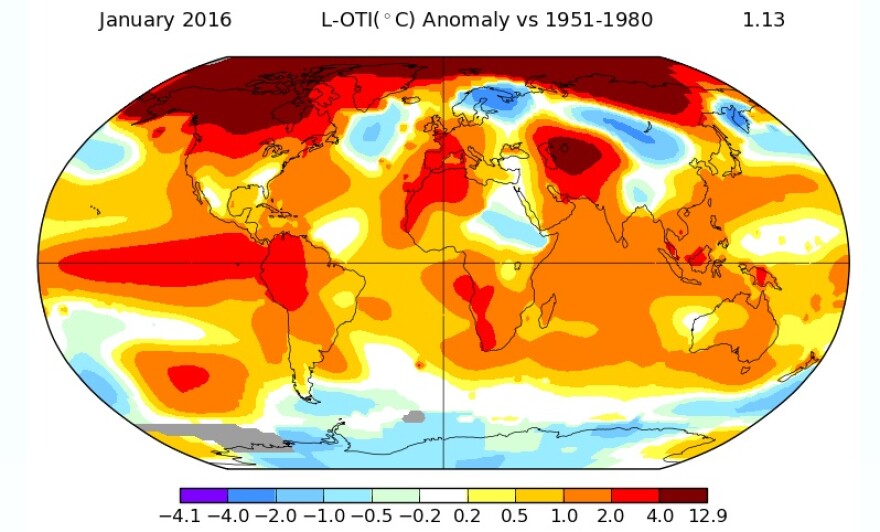
“We’ve never seen anything like this, in terms of how warm it was this January,” says Mark Serreze, a sea-ice expert with the National Snow and Ice Data Center.
“It was just crazy warm,” he said, describing the record-setting warmth that settled in over the Arctic last month.

Serreze, who directs the Denver-based National Snow and Ice Data Center, says crazy, even “absurdly,” warm temperatures in the Arctic last month reflected the record-setting warmth worldwide. NASA says it was the warmest January since record-keeping began in 1880. That continued the global trend set last year, which NASA and the National Oceanic and Atmospheric Administration says was the warmest year on record.
“I’ve really seen anything like it since I’ve been looking at the Arctic – and that’s several decades,” he said, adding that all the circumpolar warmth has led to a record-setting shortfall in the average Arctic sea-ice cover for January.
“The ice right now is at a record low,” Serreze said.

The Center reports there was less Arctic sea ice last month than any other January since the agency began satellite-tracking it 1981 – about 400,000 square miles less than the 35-year average, and significantly less sea ice than in January 2012, the year that holds the record for the lowest wintertime sea-ice extent.
Experts agree this year’s El Nino contributed to the warmer temperatures that have limited the formation of wintertime sea ice in the region. But meteorologist Rick Thoman says the warming trend began before El Nino set in last year.
“Every single October since 2001, Barrow has been significantly warmer than normal – every single one,” he said. “There’s nothing like this in the historical record going back a century.”
Thoman, a climate-science specialist with the National Weather Service’s Fairbanks office, says that trend has in turn contributed to another – the diminishing formation of Arctic sea ice, year after year.
“We can certainly attribute very warm Octobers in the last decade-and-a-half to that loss of sea ice,” he said.
Experts say if the trend continues, the circumpolar ice cap could effectively disappear during summers within 30 years.
Editor's note: This story was revised for posting online.


